Plan of City of Raleigh by William Christmas 1792
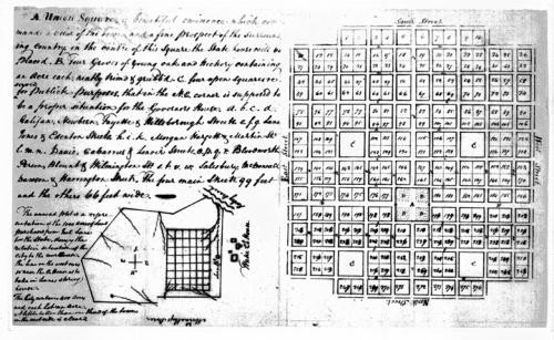
Courtesy of the North Carolina State Archives, the plan of the city of Raleigh as drawn by William Christmas in 1792. The legend on the map reads:
A.Union Square, a beautiful eminence which commands a view of the Town, and a fine prospect of the surrounding country. in the centre of this square the State house will be placed. B.Four groves of young oak and hickory containing an acre each; neatly trimd of grubb.h [sic]C. four open squares reserved for publick purposes. that in the N.E. corner is supposed to be a proper situation for the Governer's house. a.b.c.d. Halifax, Newbern, Fayette & Hillsborough Streets. e.f.g. Lane, Jones and Edenton Streets h.i.k. Morgan Hargett & Martin Sts. l.m.n. Davie, Cabarrus & Lenoir Streets o.p.q.r. Bloodworth Person, Blount & Wilmington Sts s.t.v.w. Salisbury. McDowall Dawson & Harrington Streets. the four main Streets. 99 feet and the others 66 feet wide
The annend [?] plot is a representation of the 1000 acres of land purchased from Joel Lane for the State, shewing the relative situation of the City to the court house. The line on the west runs so near the Co House as to take in Lanes spring house.
The City contains 400 acres and each lot an acre. A little better than one third of the town on the west side is cleared.